
Thank you for supporting this site ❤️
Make a donation
Make a donation
Pope Valley topographic map
Click on the map to display elevation.
Thank you for supporting this site ❤️
Make a donation
Make a donation
About this map
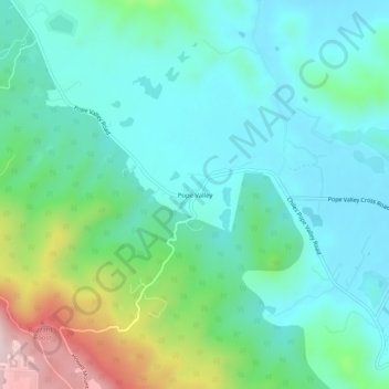
Name: Pope Valley topographic map, elevation, terrain.
Location: Pope Valley, Napa County, California, 94567, United States (38.59518 -122.44776 38.63518 -122.40776)
Average elevation: 285 m
Minimum elevation: 184 m
Maximum elevation: 609 m
Thank you for supporting this site ❤️
Make a donation
Make a donation
Other topographic maps
Click on a map to view its topography, its elevation and its terrain.