
Thank you for supporting this site ❤️
Make a donation
Make a donation
Hickory Flat topographic map
Click on the map to display elevation.
Thank you for supporting this site ❤️
Make a donation
Make a donation
About this map
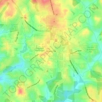
Name: Hickory Flat topographic map, elevation, terrain.
Location: Hickory Flat, Cherokee County, Georgia, 30115, United States (34.15010 -84.44270 34.19010 -84.40270)
Average elevation: 307 m
Minimum elevation: 274 m
Maximum elevation: 345 m
Thank you for supporting this site ❤️
Make a donation
Make a donation
Other topographic maps
Click on a map to view its topography, its elevation and its terrain.