
Thank you for supporting this site ❤️
Make a donation
Make a donation
Tierra Amarilla topographic map
Click on the map to display elevation.
Thank you for supporting this site ❤️
Make a donation
Make a donation
Tierra Amarilla
The Brazos Cliffs are a prominent nearby landmark and attraction. Also nearby are the artificial Heron Lake and El Vado Lake. Tierra Amarilla's elevation is 7,524 feet above sea level.
Thank you for supporting this site ❤️
Make a donation
Make a donation
About this map
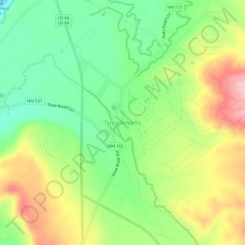
Name: Tierra Amarilla topographic map, elevation, terrain.
Average elevation: 2,318 m
Minimum elevation: 2,236 m
Maximum elevation: 2,430 m
Thank you for supporting this site ❤️
Make a donation
Make a donation
Other topographic maps
Click on a map to view its topography, its elevation and its terrain.
Ohkay Owingeh
United States > New Mexico > Rio Arriba County
Its elevation is 5,663 feet (1,726 m) and it is located at 36°03′12″N 106°04′08″W / 36.05333°N 106.06889°W / 36.05333; -106.06889. One of its boundaries is contiguous with Española, about 25 miles (40 km) north of Santa Fe.
Average elevation: 1,726 m