
Thank you for supporting this site ❤️
Make a donation
Make a donation
Pozuelo topographic map
Click on the map to display elevation.
Thank you for supporting this site ❤️
Make a donation
Make a donation
About this map
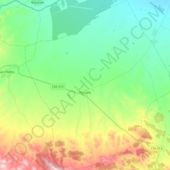
Name: Pozuelo topographic map, elevation, terrain.
Location: Pozuelo, Albacete, Castile-La Mancha, Spain (38.74434 -2.16637 38.88696 -2.00191)
Average elevation: 861 m
Minimum elevation: 710 m
Maximum elevation: 1,192 m
Thank you for supporting this site ❤️
Make a donation
Make a donation