
Thank you for supporting this site ❤️
Make a donation
Make a donation
Moroto topographic map
Click on the map to display elevation.
Thank you for supporting this site ❤️
Make a donation
Make a donation
Moroto
Moroto is located approximately 528 kilometres (328 mi), by road, northeast of Kampala, the capital and largest city of Uganda. The geographical coordinates of Moroto Town are 2°31'48.0"N, 34°40'12.0"E (Latitude:2.5300; Longitude:34.6700). Moroto sits at an average elevation of 1,370 metres (4,490 ft) above mean sea level.
Thank you for supporting this site ❤️
Make a donation
Make a donation
About this map
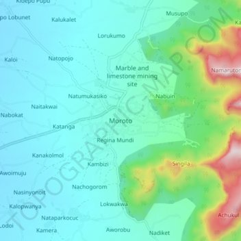
Name: Moroto topographic map, elevation, terrain.
Location: Moroto, Northern Region, Uganda (2.48862 34.61873 2.56862 34.69873)
Average elevation: 1,429 m
Minimum elevation: 1,274 m
Maximum elevation: 2,103 m
Thank you for supporting this site ❤️
Make a donation
Make a donation