
Make a donation
Almeria topographic map
Click on the map to display elevation.
Make a donation
Almeria
During the winter, daily maximum temperatures tend to stay around 17–18 °C (63–64 °F). At night, the minimum temperature is usually around 8–10 °C (47–50 °F). This makes Almería the city with the second warmest winters in Spain and Europe, just after Cádiz. The city only receives 26 days of rainfall annually; so while no month could be described as truly wet, there are strong differences in terms of rainfall, with coastal parts of the city (such as the Cabo de Gata-Níjar Natural Park) receiving a rainfall amount of 156 mm (6.1 in) per year, which is also noted as the driest location in Europe, while inland areas (such as the Tabernas Desert) receive a rainfall amount of 200 mm (7.9 in) per year, since the average altitude is 600 m (2,000 ft), and it has an average temperature of 17.9 °C (64.2 °F), so it would be classified as a cold desert climate (BWk) bordering a cold semi-arid climate (BSk) according to the Köppen climate classification.
Make a donation
About this map
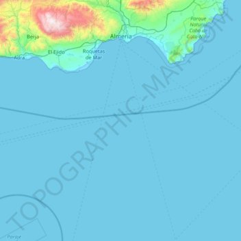
Name: Almeria topographic map, elevation, terrain.
Location: Almeria, Andalusia, Spain (35.93764 -3.03721 37.00001 -2.20220)
Average elevation: 97 m
Minimum elevation: -3 m
Maximum elevation: 2,221 m
Make a donation
Other topographic maps
Click on a map to view its topography, its elevation and its terrain.
Mijas
Spain > Andalusia > Costa del Sol Occidental > Mijas > Mijas
The climate changes gradually with increasing elevation in the mountains. Temperatures can drop to 10 °C (50 °F). In the peaks, over 600 m (2,000 ft) high, some ice may form in winter, while precipitation increases to almost 800 mm (32 in).
Average elevation: 447 m
Park Beach
Spain > Andalusia > Costa del Sol Occidental > Estepona > Park Beach
Average elevation: 13 m
Make a donation