
Thank you for supporting this site ❤️
Make a donation
Make a donation
Saint-Paul-le-Froid topographic map
Click on the map to display elevation.
Thank you for supporting this site ❤️
Make a donation
Make a donation
Saint-Paul-le-Froid
La superficie de Saint-Paul-le-Froid est de 4 417 hectares (44,17 km2) avec une altitude minimum de 1 154 mètres et un maximum de 1 469 mètres.
Thank you for supporting this site ❤️
Make a donation
Make a donation
About this map
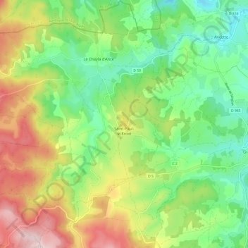
Name: Saint-Paul-le-Froid topographic map, elevation, terrain.
Average elevation: 1,249 m
Minimum elevation: 1,106 m
Maximum elevation: 1,475 m
Thank you for supporting this site ❤️
Make a donation
Make a donation
Other topographic maps
Click on a map to view its topography, its elevation and its terrain.
La Baraque de Trémolet
France > Occitanie > Lozère > Massegros Causses Gorges
Average elevation: 855 m
Thank you for supporting this site ❤️
Make a donation
Make a donation