
Thank you for supporting this site ❤️
Make a donation
Make a donation
Bhinar topographic map
Click on the map to display elevation.
Thank you for supporting this site ❤️
Make a donation
Make a donation
About this map
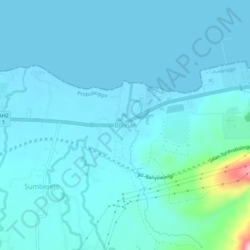
Name: Bhinar topographic map, elevation, terrain.
Location: Bhinar, Probolinggo, East Java, Java, Indonesia (-7.73938 113.53269 -7.69938 113.57269)
Average elevation: 21 m
Minimum elevation: -1 m
Maximum elevation: 217 m
Thank you for supporting this site ❤️
Make a donation
Make a donation
Other topographic maps
Click on a map to view its topography, its elevation and its terrain.
Suaka Margasatwa Dataran Tinggi Yang
Indonesia > East Java > Probolinggo > Situbondo
Average elevation: 1,885 m