
Thank you for supporting this site ❤️
Make a donation
Make a donation
Caño Quebrado topographic map
Click on the map to display elevation.
Thank you for supporting this site ❤️
Make a donation
Make a donation
About this map
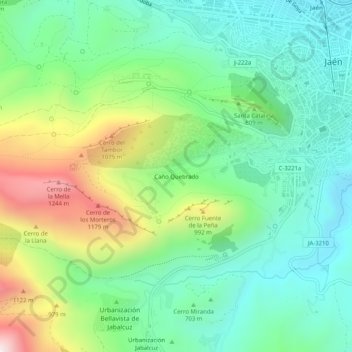
Name: Caño Quebrado topographic map, elevation, terrain.
Location: Caño Quebrado, Jaén, Andalucía, 23002, España (37.73979 -3.83092 37.77979 -3.79092)
Average elevation: 739 m
Minimum elevation: 463 m
Maximum elevation: 1,339 m
Thank you for supporting this site ❤️
Make a donation
Make a donation
Other topographic maps
Click on a map to view its topography, its elevation and its terrain.