
Thank you for supporting this site ❤️
Make a donation
Make a donation
Newcastle topographic map
Click on the map to display elevation.
Thank you for supporting this site ❤️
Make a donation
Make a donation
About this map
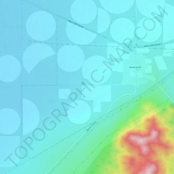
Name: Newcastle topographic map, elevation, terrain.
Location: Newcastle, Iron County, Utah, United States (37.64210 -113.58867 37.68058 -113.52985)
Average elevation: 1,661 m
Minimum elevation: 1,590 m
Maximum elevation: 1,964 m
Thank you for supporting this site ❤️
Make a donation
Make a donation
Other topographic maps
Click on a map to view its topography, its elevation and its terrain.