
Make a donation
Huangshan topographic map
Click on the map to display elevation.
Make a donation
Huangshan
Lower elevations of Huangshan City have a humid subtropical climate (Köppen Cfa), with short, cool winters and long, very hot and humid summers. At the central Tunxi District, the monthly mean temperature ranges from 4.4 °C (39.9 °F) in January to 28.1 °C (82.6 °F) in July, and the annual mean is 16.66 °C (62.0 °F). Precipitation is concentrated in spring and the earlier part of summer, and, at 1,739 mm (68.5 in) annually, is very high for the province, and more than double than the normal annual precipitation in northern parts of the province.
Make a donation
About this map
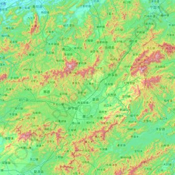
Name: Huangshan topographic map, elevation, terrain.
Location: Huangshan, Anhui, China (29.39523 117.19807 30.51939 118.89911)
Average elevation: 356 m
Minimum elevation: 5 m
Maximum elevation: 1,760 m
Make a donation
Other topographic maps
Click on a map to view its topography, its elevation and its terrain.
Huangshan
China > Anhui > Huangshan District
The vegetation of the area varies with elevation. Mesic forests cover the landscape below 1,100 meters. Deciduous forest stretches from 1,100 meters up to the tree line at 1,800 meters. Above that point, the vegetation consists of alpine grasslands. The area has diverse flora, where one-third of China's…
Average elevation: 754 m
Make a donation
Make a donation
Make a donation
Make a donation
Make a donation
Make a donation