
Kirchhundem topographic map
Interactive map
Click on the map to display elevation.
About this map
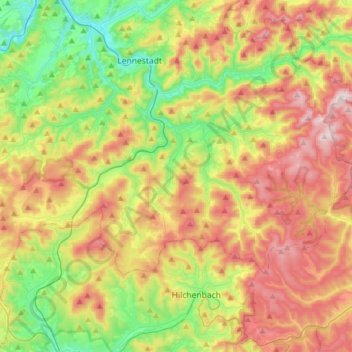
Name: Kirchhundem topographic map, elevation, terrain.
Location: Kirchhundem, Kreis Olpe, Noordrijn-Westfalen, 57399, Duitsland (51.00495 7.93392 51.11480 8.24657)
Average elevation: 462 m
Minimum elevation: 237 m
Maximum elevation: 752 m
Other topographic maps
Click on a map to view its topography, its elevation and its terrain.
Wenden
Duitsland > Noordrijn-Westfalen > Kreis Olpe
Wenden, Kreis Olpe, Noordrijn-Westfalen, 57482, Duitsland
Average elevation: 399 m
Bieberg
Duitsland > Noordrijn-Westfalen > Kreis Olpe > Wenden
Bieberg, Wenden, Kreis Olpe, Noordrijn-Westfalen, 57482, Duitsland
Average elevation: 379 m
Atta-Höhle
Duitsland > Noordrijn-Westfalen > Kreis Olpe > Attendorn
Atta-Höhle, Finnentroper Straße, Attendorn, Kreis Olpe, Noordrijn-Westfalen, 57439, Duitsland
Average elevation: 312 m
Schliprüthen
Duitsland > Noordrijn-Westfalen > Kreis Olpe > Finnentrop
Schliprüthen, Finnentrop, Kreis Olpe, Noordrijn-Westfalen, 57413, Duitsland
Average elevation: 472 m
Hollberg
Duitsland > Noordrijn-Westfalen > Kreis Olpe > Lennestadt
Hollberg, Lennestadt, Kreis Olpe, Noordrijn-Westfalen, 57368, Duitsland
Average elevation: 325 m
Kruberg
Duitsland > Noordrijn-Westfalen > Kreis Olpe > Olpe
Kruberg, Olpe, Kreis Olpe, Noordrijn-Westfalen, Duitsland
Average elevation: 440 m
Drolshagen
Duitsland > Noordrijn-Westfalen > Kreis Olpe > Drolshagen
Drolshagen, Kreis Olpe, Noordrijn-Westfalen, 57489, Duitsland
Average elevation: 396 m
Biggesee
Duitsland > Noordrijn-Westfalen > Kreis Olpe > Olpe > Sondern
Biggesee, Sondern, Olpe, Kreis Olpe, Noordrijn-Westfalen, Duitsland
Average elevation: 387 m
Lennestadt
Duitsland > Noordrijn-Westfalen > Kreis Olpe
Lennestadt, Kreis Olpe, Noordrijn-Westfalen, 57368, Duitsland
Average elevation: 422 m
Rührberg
Duitsland > Noordrijn-Westfalen > Kreis Olpe > Finnentrop
Rührberg, Finnentrop, Kreis Olpe, Noordrijn-Westfalen, Duitsland
Average elevation: 458 m
Finnentrop
Duitsland > Noordrijn-Westfalen > Kreis Olpe
Finnentrop, Kreis Olpe, Noordrijn-Westfalen, 57413, Duitsland
Average elevation: 380 m
Attendorn
Duitsland > Noordrijn-Westfalen > Kreis Olpe
Attendorn, Kreis Olpe, Noordrijn-Westfalen, 57439, Duitsland
Average elevation: 384 m
Olpe
Duitsland > Noordrijn-Westfalen > Kreis Olpe
Olpe, Kreis Olpe, Noordrijn-Westfalen, 57462, Duitsland
Average elevation: 400 m