
Make a donation
Sutlej River topographic map
Click on the map to display elevation.
Make a donation
Sutlej River
There is substantial geologic evidence to indicate that prior to 1700 BC, and perhaps much earlier, the Sutlej was an important tributary of the Ghaggar-Hakra River (thought to be the legendary Sarasvati River) rather than the Indus, with various authors putting the redirection from 2500 to 2000 BC, from 5000 to 3000 BC, or before 8000 BC. Geologists believe that tectonic activity created elevation changes which redirected the flow of Sutlej from the southeast to the southwest. If the diversion of the river occurred recently (about 4000 years ago), it may have been responsible for the Ghaggar-Hakra (Saraswati) drying up, causing desertification of Cholistan and the eastern part of the modern state of Sindh, and the abandonment of Harappan settlements along the Ghaggar. However, the Sutlej may have already been captured by the Indus thousands of years earlier.
Make a donation
About this map
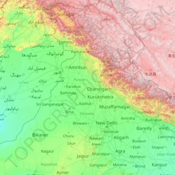
Name: Sutlej River topographic map, elevation, terrain.
Location: Sutlej River, India (29.35226 71.05994 31.84358 81.08621)
Average elevation: 1,496 m
Minimum elevation: 95 m
Maximum elevation: 6,949 m
Make a donation
Other topographic maps
Click on a map to view its topography, its elevation and its terrain.
Kolkata
Spread roughly north–south along the east bank of the Hooghly River, Kolkata sits within the lower Ganges Delta of eastern India approximately 75 km (47 mi) west of the international border with Bangladesh; the city's elevation is 1.5–9 m (5–30 ft). Much of the city was originally a wetland that was…
Average elevation: 5 m
Hosur
India > Tamil Nadu > Hosur
Hosur experiences a tropical savanna climate (Köppen climate classification) with distinct wet and dry seasons. Due to its high elevation, Hosur usually enjoys salubrious and moderate climate throughout the year, with occasional heat waves. The coolest month is January with an average low temperature of 17.1…
Average elevation: 859 m
Make a donation
Chandigarh
India > Chandigarh > Chandigarh > Chandigarh
Chandigarh is located near the foothills of the Sivalik range of the Himalayas in northwest India. It covers an area of approximately 114 km2. It borders the states of Haryana and Punjab. The exact geographic co-ordinates of Chandigarh are 30°44′N 76°47′E / 30.74°N 76.79°E / 30.74; 76.79. It…
Average elevation: 378 m
Surat
India > Gujarat > Katargam Taluka > Surat
Surat is a port city situated on the banks of the Tapi river. Damming of the Tapi caused the original port facilities to close; the nearest port is now in the Magadalla and Hazira area of Surat Metropolitan Region.It has famous beach called 'Dumas Beach' located in Hazira. The city is located at 21°10′N…
Average elevation: 11 m
Rishikesh
India > Uttarakhand > Rishikesh
Rishikesh is at 30°06′12″N 78°17′41″E / 30.103368°N 78.294754°E / 30.103368; 78.294754. It has an average elevation of 372 metres (1,220 ft). The town is located in the Tehri Garhwal region of the northern Indian state of Uttarakhand.
Average elevation: 497 m
Agra
India > Uttar Pradesh > Agra
The region around Agra consists almost entirely of a level plain, with hills in the extreme southwest. The rivers in the region include Yamuna and Chambal. The region is also watered by the Agra Canal. Millet, barley, wheat and cotton are among the crops grown in the surrounding countryside. Both Rabi and…
Average elevation: 166 m
Make a donation
Make a donation
Make a donation
Haldwani
India > Uttarakhand > Haldwani
Haldwani is located at 29°13′N 79°31′E / 29.22°N 79.52°E / 29.22; 79.52, in the Nainital district on the right bank of the Gaula River. Geologically, Haldwani is settled on a piedmont grade (called Bhabhar) where the mountain rivers go underground to re-emerge in the Indo-Gangetic plain. The…
Average elevation: 673 m
Make a donation
Shimla
India > Himachal Pradesh > Shimla (urban)
Shimla is on the south-western ranges of the Himalayas at 31°37′N 77°06′E / 31.61°N 77.10°E / 31.61; 77.10. It has an average altitude of 2,206 metres (7,238 ft) above mean sea level and extends along a ridge with seven spurs. The city stretches nearly 9.2 kilometres (5.7 mi) from east to west.
Average elevation: 1,557 m
Make a donation
Pimpri-Chinchwad
India > Maharashtra > Haveli
Pimpri-Chinchwad also known as "PCMC", is a city in the Indian state of Maharashtra. The city is about 15 km (9.3 mi) northwest of the historic city of Pune, at an altitude of 590 m (1,940 ft) above sea level. It is the fifth largest city in Maharashtra and the nineteenth largest city in India and the…
Average elevation: 605 m
Kottayam
Kottayam has an average elevation of 3 metres (9.8 ft) above sea level. and is situated in the basin of the Meenachil River and in the basin of the Vembanad backwaters, which are formed from several streams in the Western Ghats in Idukki district. According to the division of places in Kerala based on…
Average elevation: 19 m
Make a donation
Nagaur
India > Rajasthan > Nagaur Tehsil
Nagaur is located at 27°12′N 73°44′E / 27.2°N 73.73°E / 27.2; 73.73. It has an average elevation of 302 metres (990 feet). Nagaur is situated amidst seven districts namely Bikaner, Churu, Sikar, Jaipur, Ajmer, Pali, Jodhpur. Nagaur is the fifth largest district in Rajasthan with a vast terrain…
Average elevation: 303 m
Nainital
India > Uttarakhand > Nainital
The city of Nainital covers a total area of 11.73 km2 (4.53 sq mi), and is located at 29°23′N 79°27′E / 29.38°N 79.45°E / 29.38; 79.45, at an average elevation of 2,084 metres (6,837 ft) above sea level. The slopes of the nearby mountains are most populated, with an elevation ranging from…
Average elevation: 1,813 m
Make a donation
Gandhinagar
India > Gujarat > Gandhinagar Taluka > Gandhinagar
Gandhinagar has an average elevation of 81 metres (266 feet). The city sits on the banks of the Sabarmati River, in north-central-east Gujarat. The 20,543 km2 area around Gandhinagar is defined by Gujarat capital territory. It spans an area of 205 km2 (79 sq mi). The river frequently dries up in the summer,…
Average elevation: 76 m
Almora
India > Uttarakhand > Almora
Almora is located at 29°35′50″N 79°39′33″E / 29.5971°N 79.6591°E / 29.5971; 79.6591 in Almora district in Uttarakhand. Almora is situated 365 km north-east the national capital New Delhi and 415 km south-east the state capital Dehradun. It lies in the revenue Division Kumaon and is located…
Average elevation: 1,557 m
Make a donation
Pahalgam
India > Jammu and Kashmir > Pahalgam
Pahalgam (Hindustani pronunciation: [pɛhɛlɡaːm]), known as Pahalgom (Kashmiri pronunciation: [pəhəlʲɡoːm]; lit. 'village of shepherds' in Kashmiri) is a town and a notified area committee, near Anantnag city in the Anantnag district of the Indian-administered union territory of Jammu and Kashmir. It…
Average elevation: 2,700 m
Gauribidanuru
India > Karnataka > Gauribidanuru taluk
Gauribidanur is at 13°37′N 77°31′E / 13.61°N 77.52°E / 13.61; 77.52. It has an average elevation of 694 metres (2276 feet).
Average elevation: 691 m
Make a donation
ChengiCherla Cheruvu aka Pochamma Kunta
India > Telangana > Medipally mandal > Chengicherla
Average elevation: 510 m
Make a donation
Gaya
India > Bihar > Gaya Town C.D.Block
Gaya is connected to the rest of India by roads, rail and airways. The Grand Chord section of the Indian Railways passes through Gaya. Gaya Junction railway station railway station is a major junction station serving the city. Gaya Junction has been redeveloped as Model railway station recently and houses all…
Average elevation: 111 m
Make a donation
North Paravur
Paravur is located at 10.14° N 76.7° E[1]. It has an average elevation of 10 metres (32 feet). The town is situated at north end of Ernakulam district and bordering with Thrissur district. The towns in Thrissur district like Kodungallore, Mala, Chalakudy and the towns Kalamassery, Aluva, Angamaly, Vypin…
Average elevation: 5 m
Baraut
India > Uttar Pradesh > Baraut
Baraut is located at 29.6°N 77.16°E, covering an area of 10.36 square kilometers (4.00 sq mi) and lying between the Ganga and Yamuna river plains. Its average elevation is 231 m (758 feet). Baraut is served by NH-709B and state highways SH-57 and SH-82.
Average elevation: 227 m
Shantipur
India > West Bengal > Santipur
Santipur is located at 23°15′N 88°26′E / 23.25°N 88.43°E / 23.25; 88.43. It has an average elevation of 15 metres (49 feet).
Average elevation: 11 m
Make a donation
Vellore Fort
India > Tamil Nadu > Vellore > Vellore
It is mentioned that "there is no such fort on the face of earth like the one in Vellore. It had a deep wet ditch (moat) where once 10,000 crocodiles swarmed, waiting to grab every intruder into this impregnable fort. It has huge double walls with bastions projecting irregularly, where two carts can be driven…
Average elevation: 214 m
Make a donation
Make a donation
Adilabad
India > Telangana > Adilabad Urban Mandal
Adilabad has an average elevation of 264 metres. The district shares its boundaries with Nirmal districts of Telangana to the south, Komaram Bheem district on the east, with Nanded on the west and Yavatmal and Chandrapur districts of Maharashtra to the north.
Average elevation: 310 m
Make a donation
Make a donation
Alnavar
India > Karnataka > Alnavara taluku
Alnavar is located at 15°26′N 74°44′E / 15.43°N 74.73°E / 15.43; 74.73. It has an average elevation of 563 metres (1847 feet). Trains from Bangalore to Vasco da Gama passes through this town.
Average elevation: 575 m
Make a donation
Didwana
India > Rajasthan > Didwana Tehsil
Didwana is located at 27°24′N 74°34′E / 27.4°N 74.57°E / 27.4; 74.57. It has an average elevation of 336 metres (1102 feet). City divided in 40 Wards. It is an important station of Jodhpur-Delhi Broad gauge rail route of North West Railway Jodhpur division.
Average elevation: 343 m
Make a donation
Make a donation
Make a donation
Udupi
India > Karnataka > Udupi taluku
Udupi has an elevation of 27 m (89 ft) above mean sea level. The climate in Udupi is hot in summers and pleasant in winter. During summers (from March to May) the temperature reaches up to 38 °C (100 °F) and in winters (from December to February) it is usually between 32 and 20 °C (90 and 68 °F). As it is…
Average elevation: 17 m
Make a donation
Bardhaman
India > West Bengal > Burdwan - I > Bardhaman
The region has an average elevation of 40 metres (131 ft). The city is situated 1100 km from New Delhi and a little less than 100 km north-west of Kolkata on the Grand Trunk Road (National Highway 19) and Eastern Railway. The chief rivers are the Damodar and the Banka.
Average elevation: 30 m
Make a donation
Mirik
India > West Bengal > Mirik Subdivision > Mirik
Mirik has an average elevation of 1,495 m (4,905 ft). The highest point is the Boker Monastery at about 1,768 m (5,801 ft). Mirik lake at about 1,494 m (4,902 ft) is the lowest point. Mirik is 52 km (32 mi) northwest of Siliguri city and 49 km (30 mi) south-southwest of Darjeeling town. Mirik subdivision. The…
Average elevation: 1,156 m
Make a donation
Kalavad
India > Gujarat > Kalavad Taluka
Kalavad is located at 22°13′N 70°23′E / 22.22°N 70.38°E / 22.22; 70.38. It has an average elevation of 87 metres (285 feet).
Average elevation: 100 m
Make a donation