
Make a donation
Converse topographic map
Click on the map to display elevation.
Make a donation
About this map
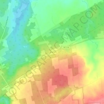
Name: Converse topographic map, elevation, terrain.
Average elevation: 188 m
Minimum elevation: 143 m
Maximum elevation: 239 m
Make a donation
Other topographic maps
Click on a map to view its topography, its elevation and its terrain.
DeKalb Junction
United States > New York > Saint Lawrence County > Town of De Kalb
Average elevation: 131 m
Make a donation
Village of Rensselaer Falls
United States > New York > Saint Lawrence County > Town of Canton
Average elevation: 98 m
Star Lake
United States > New York > Saint Lawrence County > Town of Fine > Star Lake
Average elevation: 443 m
Town of Hammond
United States > New York > Saint Lawrence County > Town of Hammond
The Village of Hammond is located at 44°26′56″N 75°41′39″W / 44.44889°N 75.69417°W / 44.44889; -75.69417Coordinates: 44°26′56″N 75°41′39″W / 44.44889°N 75.69417°W / 44.44889; -75.69417. The elevation is 358 feet (109 m).
Average elevation: 99 m
Make a donation
Cedar Island State Park
United States > New York > Saint Lawrence County > Town of Hammond
Average elevation: 74 m
Sylvia Lake
United States > New York > Saint Lawrence County > Town of Fowler
Average elevation: 204 m
Make a donation
Make a donation
Village of Hammond
United States > New York > Saint Lawrence County > Village of Hammond
Average elevation: 109 m
Brasher Falls
United States > New York > Saint Lawrence County > Brasher Falls
Average elevation: 96 m
Make a donation