
Winster CP topographic map
Click on the map to display elevation.
Winster CP
Winster is a village in the English Derbyshire Dales about 5 miles (8 km) from Matlock and 6 miles (10 km) from Bakewell at an altitude of approximately 820 feet (250 m). It was formerly a centre for the lead mining industry. The village lies within the Peak District National Park and The Peak District Boundary Walk runs through the village. Winster has many listed buildings, including the Market House open daily as a National Trust information point. Its current population is about 630, though it was 600 at the 2011 Census. The village has a primary school, two churches, two pubs and a village shop (owned by the community) which includes a post office. Winster was mentioned in the Domesday Book in 1086 when it was owned by Henry de Ferrers.
About this map
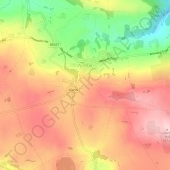
Name: Winster CP topographic map, elevation, terrain.
Average elevation: 274 m
Minimum elevation: 137 m
Maximum elevation: 367 m
Other topographic maps
Click on a map to view its topography, its elevation and its terrain.
Hallam Moors
United Kingdom > England > Derbyshire > Derbyshire Dales > Hathersage
Average elevation: 368 m
Slaley
United Kingdom > England > Derbyshire > Derbyshire Dales > Matlock > Bonsall CP
Average elevation: 263 m
Bolehill
United Kingdom > England > Derbyshire > Derbyshire Dales > Wirksworth CP
Average elevation: 220 m
Riber Castle
United Kingdom > England > Derbyshire > Derbyshire Dales > Matlock > Starkholmes
Average elevation: 169 m
Monsal Head
United Kingdom > England > Derbyshire > Derbyshire Dales > Cressbrook > Monsal Head
Average elevation: 231 m
Parsley Hay
United Kingdom > England > Derbyshire > Derbyshire Dales > Parsley Hay
Average elevation: 334 m
Arbor Low
United Kingdom > England > Derbyshire > Derbyshire Dales > Parsley Hay
Average elevation: 342 m
Two Dales
United Kingdom > England > Derbyshire > Derbyshire Dales > Darley Dale CP > Darley Hillside
Average elevation: 189 m
Starkholmes
United Kingdom > England > Derbyshire > Derbyshire Dales > Matlock
Average elevation: 175 m
Farley Wood
United Kingdom > England > Derbyshire > Derbyshire Dales > Matlock
Average elevation: 255 m
Magpie Mine
United Kingdom > England > Derbyshire > Derbyshire Dales > Ashford in the Water CP
Average elevation: 303 m
Catcliff Wood
United Kingdom > England > Derbyshire > Derbyshire Dales > Bakewell CP
Average elevation: 173 m
Gang Mine
United Kingdom > England > Derbyshire > Derbyshire Dales > Cromford CP
Average elevation: 226 m
Taddington Dale
United Kingdom > England > Derbyshire > Derbyshire Dales > Brushfield CP
Average elevation: 281 m
Cressbrook Dale
United Kingdom > England > Derbyshire > Derbyshire Dales > Litton CP > Litton Mill
Average elevation: 286 m
Curbar Edge
United Kingdom > England > Derbyshire > Derbyshire Dales > Curbar CP
Average elevation: 252 m
Hathersage Booths
United Kingdom > England > Derbyshire > Derbyshire Dales > Hathersage
Average elevation: 260 m
Stanage Plantation
United Kingdom > England > Derbyshire > Derbyshire Dales > Hathersage
Average elevation: 360 m
Black Rocks
United Kingdom > England > Derbyshire > Derbyshire Dales > Cromford CP
Average elevation: 199 m
Padley Gorge
United Kingdom > England > Derbyshire > Derbyshire Dales > Grindleford
Average elevation: 316 m
Horseshoe Quarry
United Kingdom > England > Derbyshire > Derbyshire Dales > Eyam CP
Average elevation: 293 m
Curbar Edge
United Kingdom > England > Derbyshire > Derbyshire Dales > Calver Sough
Average elevation: 251 m
Calver Sough
United Kingdom > England > Derbyshire > Derbyshire Dales > Calver Sough
Average elevation: 218 m
Breamfield
United Kingdom > England > Derbyshire > Derbyshire Dales > Wirksworth CP > Breamfield
Average elevation: 213 m
Coplow Dale
United Kingdom > England > Derbyshire > Derbyshire Dales > Little Hucklow
Average elevation: 333 m
Stoke Brook
United Kingdom > England > Derbyshire > Derbyshire Dales > Calver Sough
Average elevation: 197 m
Longstone Edge
United Kingdom > England > Derbyshire > Derbyshire Dales > Rowland
Average elevation: 290 m
Longcliffe
United Kingdom > England > Derbyshire > Derbyshire Dales > Brassington CP
Average elevation: 299 m
Lathkill Dale
United Kingdom > England > Derbyshire > Derbyshire Dales > Youlgreave
Average elevation: 269 m
Yarncliff Wood
United Kingdom > England > Derbyshire > Derbyshire Dales > Grindleford
Average elevation: 260 m
Breamfield
United Kingdom > England > Derbyshire > Derbyshire Dales > Wirksworth CP
Average elevation: 213 m
Padley Gorge
United Kingdom > England > Derbyshire > Derbyshire Dales > Grindleford
Average elevation: 316 m
Wirksworth Moor
United Kingdom > England > Derbyshire > Derbyshire Dales > Wirksworth CP
Average elevation: 207 m