
Thank you for supporting this site ❤️
Make a donation
Make a donation
Limoges topographic map
Click on the map to display elevation.
Thank you for supporting this site ❤️
Make a donation
Make a donation
About this map
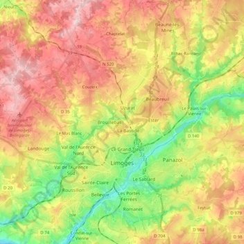
Name: Limoges topographic map, elevation, terrain.
Average elevation: 322 m
Minimum elevation: 204 m
Maximum elevation: 439 m
Thank you for supporting this site ❤️
Make a donation
Make a donation
Other topographic maps
Click on a map to view its topography, its elevation and its terrain.
Moulin de la Locherie
France > Nouvelle-Aquitaine > Haute-Vienne > Oradour-Saint-Genest
Average elevation: 201 m
La Guérite
France > Nouvelle-Aquitaine > Haute-Vienne > Maisonnais-sur-Tardoire
Average elevation: 248 m
Les Rieux Vieux
France > Nouvelle-Aquitaine > Haute-Vienne > Saint-Pardoux-le-Lac
Average elevation: 380 m
Thank you for supporting this site ❤️
Make a donation
Make a donation
Puy Chaffrat
France > Nouvelle-Aquitaine > Haute-Vienne > Les Grands-Chézeaux
Average elevation: 281 m
Thank you for supporting this site ❤️
Make a donation
Make a donation
Thank you for supporting this site ❤️
Make a donation
Make a donation