
Thank you for supporting this site ❤️
Make a donation
Make a donation
Ardisana topographic map
Click on the map to display elevation.
Thank you for supporting this site ❤️
Make a donation
Make a donation
About this map
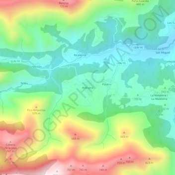
Name: Ardisana topographic map, elevation, terrain.
Location: Ardisana, Llanes, Asturias, España (43.36633 -4.96294 43.40633 -4.92294)
Average elevation: 318 m
Minimum elevation: 49 m
Maximum elevation: 814 m
Thank you for supporting this site ❤️
Make a donation
Make a donation
Other topographic maps
Click on a map to view its topography, its elevation and its terrain.