
Jevoumont topographic map
Interactive map
Click on the map to display elevation.
About this map
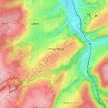
Name: Jevoumont topographic map, elevation, terrain.
Location: Jevoumont, Theux, Verviers, Luik, Wallonië, 4910, België (50.50375 5.78237 50.54375 5.82237)
Average elevation: 252 m
Minimum elevation: 155 m
Maximum elevation: 347 m
Other topographic maps
Click on a map to view its topography, its elevation and its terrain.
Sur le Thier
België > Luik > Verviers > Theux
Sur le Thier, La Reid, Theux, Verviers, Luik, Wallonië, 4910, België
Average elevation: 334 m
Hauts Marais
België > Luik > Verviers > Theux
Hauts Marais, La Reid, Theux, Verviers, Luik, Wallonië, 4910, België
Average elevation: 353 m
Vert Buisson
België > Luik > Verviers > Theux
Vert Buisson, La Reid, Theux, Verviers, Luik, Wallonië, 4910, België
Average elevation: 403 m
Sasserotte
België > Luik > Verviers > Theux
Sasserotte, Theux, Verviers, Luik, Wallonië, 4910, België
Average elevation: 270 m