
Make a donation
Nuevo topographic map
Click on the map to display elevation.
Make a donation
About this map
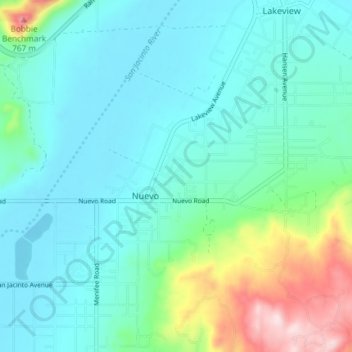
Name: Nuevo topographic map, elevation, terrain.
Location: Nuevo, Riverside County, California, United States (33.78674 -117.16704 33.82412 -117.09331)
Average elevation: 505 m
Minimum elevation: 427 m
Maximum elevation: 808 m
Make a donation
Other topographic maps
Click on a map to view its topography, its elevation and its terrain.
Indio
United States > California > Riverside County
Indio is home of Riverside County's eastern administration offices. Palm Springs had more people from 1955 to 1992, when the US census announced that Indio surpassed Palm Springs and that title was returned to them. The official elevation of Indio is below sea level; the city hall is 14 feet (4 m) below sea…
Average elevation: 74 m
Desert Hot Springs
United States > California > Riverside County
Summer winds and the higher elevation keep Desert Hot Springs on average 5-7 degrees cooler than other communities in Coachella Valley. However, the winter season can be warmer due to the surrounding mountains blocking north winds. Since it lies at a higher elevation than the cities further south, cold air…
Average elevation: 498 m
Palm Springs
United States > California > Riverside County
One possible origin of palm in the place name comes from early Spanish explorers who referred to the area as La Palma de la Mano de Dios or "The Palm of God's hand". The earliest use of the name "Palm Springs" is from United States Topographical Engineers who used the term in 1853 maps. According to William…
Average elevation: 859 m
Santa Rosa and San Jacinto Mountains National Monument
United States > California > Riverside County
The differences in elevation, temperature, and moisture give rise to diverse vegetation. Being the western boundary of the Sonoran Desert, the eastern mountainslopes are hotter and drier, while the western side is affected by the Pacific Ocean and receives more precipitation with cooler temperatures. There are…
Average elevation: 900 m
Make a donation
Coachella
United States > California > Riverside County
The elevation is 68 feet (21 m) below sea level, as the eastern half of the Coachella Valley is below sea level. The saltwater lake, Salton Sea, 10 miles (16 km) south of Coachella, is 228 feet (69 m) below sea level.
Average elevation: -2 m
Make a donation
La Quinta
United States > California > Riverside County
According to the United States Census Bureau, the city has a total area of 35.6 square miles (92 km2), of which 35.1 square miles (91 km2) is land and 0.4 square miles (1.0 km2) (1.22%) is water. The city's elevation is 56 feet (20 m) above sea level.
Average elevation: 201 m
Make a donation