
Thank you for supporting this site ❤️
Make a donation
Make a donation
Agastmuni topographic map
Click on the map to display elevation.
Thank you for supporting this site ❤️
Make a donation
Make a donation
About this map
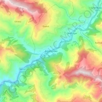
Name: Agastmuni topographic map, elevation, terrain.
Location: Agastmuni, Rudraprayag, Uttarakhand, 246421, India (30.35196 78.98604 30.43196 79.06604)
Average elevation: 1,270 m
Minimum elevation: 720 m
Maximum elevation: 2,088 m
Thank you for supporting this site ❤️
Make a donation
Make a donation