
Thank you for supporting this site ❤️
Make a donation
Make a donation
Long Kali topographic map
Click on the map to display elevation.
Thank you for supporting this site ❤️
Make a donation
Make a donation
About this map
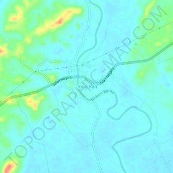
Name: Long Kali topographic map, elevation, terrain.
Location: Long Kali, Paser, East Kalimantan, Kalimantan, Indonesia (-1.54144 116.30350 -1.50144 116.34350)
Average elevation: 12 m
Minimum elevation: 1 m
Maximum elevation: 62 m
Thank you for supporting this site ❤️
Make a donation
Make a donation
Other topographic maps
Click on a map to view its topography, its elevation and its terrain.