Geolocate

Fort Salonga topographic map

Interactive map

Click on the map to display elevation.

About this map

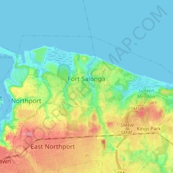
Name: Fort Salonga topographic map, elevation, terrain.

Location: Fort Salonga, Town of Huntington, Suffolk County, New York, United States (40.88116 -73.35149 40.93550 -73.23036)

Average elevation: 26 m

Minimum elevation: -1 m

Maximum elevation: 90 m

Other topographic maps

Click on a map to view its topography, its elevation and its terrain.

East Northport

United States > New York > Suffolk County > Town of Huntington

East Northport, Town of Huntington, Suffolk County, New York, 11731, United States

Average elevation: 54 m

Melville

United States > New York > Suffolk County > Town of Huntington

Melville, Town of Huntington, Suffolk County, New York, 11747, United States

Average elevation: 53 m

Commack

United States > New York > Suffolk County > Town of Huntington

Commack, Town of Huntington, Suffolk County, New York, 11725, United States

Average elevation: 51 m

Eatons Neck

United States > New York > Suffolk County > Town of Huntington

Eatons Neck, Town of Huntington, Suffolk County, New York, United States

Average elevation: 5 m

Village of Lloyd Harbor

United States > New York > Suffolk County > Town of Huntington

Village of Lloyd Harbor, Town of Huntington, Suffolk County, New York, United States

Average elevation: 14 m

Huntington Station

United States > New York > Suffolk County > Town of Huntington

Huntington Station, Town of Huntington, Suffolk County, New York, United States

Average elevation: 60 m

Village of Northport

United States > New York > Suffolk County > Town of Huntington

Village of Northport, Town of Huntington, Suffolk County, New York, 11768, United States

Average elevation: 27 m