
Thank you for supporting this site ❤️
Make a donation
Make a donation
Lyndon topographic map
Click on the map to display elevation.
Thank you for supporting this site ❤️
Make a donation
Make a donation
About this map
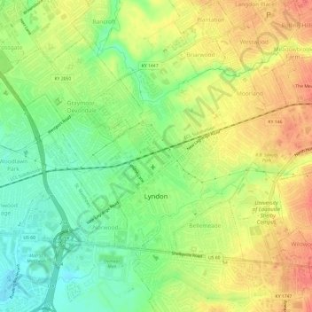
Name: Lyndon topographic map, elevation, terrain.
Location: Lyndon, Jefferson County, Kentucky, 40222, United States (38.24639 -85.61771 38.27921 -85.55771)
Average elevation: 182 m
Minimum elevation: 155 m
Maximum elevation: 207 m
Thank you for supporting this site ❤️
Make a donation
Make a donation
Other topographic maps
Click on a map to view its topography, its elevation and its terrain.
Falls of the Ohio State Park
United States > Kentucky > Jefferson County > Louisville
Average elevation: 135 m
Jefferson Memorial Forest
United States > Kentucky > Jefferson County > Louisville
Average elevation: 164 m
Louisville-Jefferson County (Balance)
United States > Kentucky > Jefferson County > Louisville
Average elevation: 157 m
Thank you for supporting this site ❤️
Make a donation
Make a donation
Thank you for supporting this site ❤️
Make a donation
Make a donation
Bellewood
United States > Kentucky > Jefferson County > St. Matthews > Bellewood
Average elevation: 167 m