
la Corbeille topographic map
Interactive map
Click on the map to display elevation.
About this map
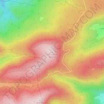
Name: la Corbeille topographic map, elevation, terrain.
Average elevation: 734 m
Minimum elevation: 480 m
Maximum elevation: 894 m
Other topographic maps
Click on a map to view its topography, its elevation and its terrain.
Col du Donon
France > Grand Est > Bas-Rhin > Grandfontaine
Col du Donon, Haut Donon, Grandfontaine, Molsheim, Bas-Rhin, Grand Est, France métropolitaine, 67130, France
Average elevation: 694 m
Colonne
France > Grand Est > Bas-Rhin > Grandfontaine
Colonne, D 392, Grandfontaine, Molsheim, Bas-Rhin, Grand Est, France métropolitaine, 67130, France
Average elevation: 684 m