
Thank you for supporting this site ❤️
Make a donation
Make a donation
Logan Village topographic map
Click on the map to display elevation.
Thank you for supporting this site ❤️
Make a donation
Make a donation
About this map
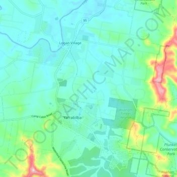
Name: Logan Village topographic map, elevation, terrain.
Location: Logan Village, Greater Brisbane, Queensland, Australia (-27.82866 153.06781 -27.74988 153.16289)
Average elevation: 52 m
Minimum elevation: 4 m
Maximum elevation: 239 m
Thank you for supporting this site ❤️
Make a donation
Make a donation
Other topographic maps
Click on a map to view its topography, its elevation and its terrain.