
Thank you for supporting this site ❤️
Make a donation
Make a donation
Rogersville topographic map
Click on the map to display elevation.
Thank you for supporting this site ❤️
Make a donation
Make a donation
About this map
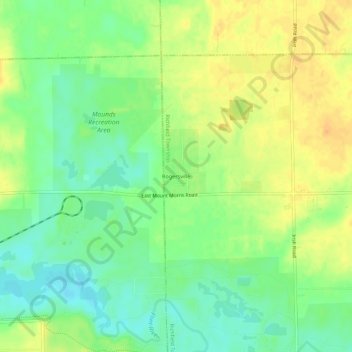
Name: Rogersville topographic map, elevation, terrain.
Location: Rogersville, Genesee County, Michigan, 48437, United States (43.10280 -83.59690 43.14280 -83.55690)
Average elevation: 232 m
Minimum elevation: 215 m
Maximum elevation: 248 m
Thank you for supporting this site ❤️
Make a donation
Make a donation
Other topographic maps
Click on a map to view its topography, its elevation and its terrain.
Thank you for supporting this site ❤️
Make a donation
Make a donation
Thank you for supporting this site ❤️
Make a donation
Make a donation
Thank you for supporting this site ❤️
Make a donation
Make a donation
Thank you for supporting this site ❤️
Make a donation
Make a donation