
Make a donation
Hope Mills topographic map
Click on the map to display elevation.
Make a donation
About this map
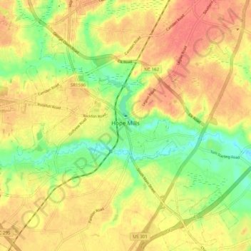
Name: Hope Mills topographic map, elevation, terrain.
Location: Hope Mills, Cumberland County, North Carolina, United States (34.92947 -78.99355 35.00970 -78.90120)
Average elevation: 49 m
Minimum elevation: 19 m
Maximum elevation: 69 m
Make a donation
Other topographic maps
Click on a map to view its topography, its elevation and its terrain.
Atlantic Coastal Plain
United States > North Carolina > Cumberland County > Fayetteville
The province's average elevation is less than 900 meters above sea level and extends some 50 to 100 kilometers inland from the ocean. The coastal plain is normally wet, including many rivers, marsh, and swampland. It is composed primarily of sedimentary rock and unlithified sediments and is primarily used for…
Average elevation: 51 m
Edenroc
United States > North Carolina > Cumberland County > Fayetteville > Edenroc
Average elevation: 57 m
Make a donation