
Thank you for supporting this site ❤️
Make a donation
Make a donation
Otero del Monte topographic map
Click on the map to display elevation.
Thank you for supporting this site ❤️
Make a donation
Make a donation
About this map
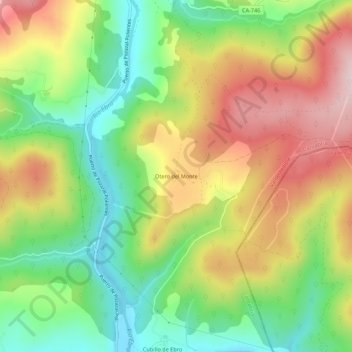
Name: Otero del Monte topographic map, elevation, terrain.
Location: Otero del Monte, Valderredible, Cantabria, 39250, España (42.80801 -4.05006 42.84801 -4.01006)
Average elevation: 873 m
Minimum elevation: 723 m
Maximum elevation: 1,056 m
Thank you for supporting this site ❤️
Make a donation
Make a donation
Other topographic maps
Click on a map to view its topography, its elevation and its terrain.