
Thank you for supporting this site ❤️
Make a donation
Make a donation
Ampel topographic map
Click on the map to display elevation.
Thank you for supporting this site ❤️
Make a donation
Make a donation
About this map
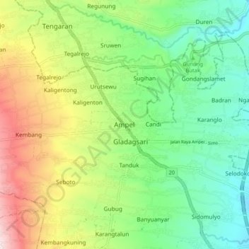
Name: Ampel topographic map, elevation, terrain.
Location: Ampel, Boyolali, Central Java, Java, 57352, Indonesia (-7.49192 110.50359 -7.41192 110.58359)
Average elevation: 701 m
Minimum elevation: 482 m
Maximum elevation: 1,093 m
Thank you for supporting this site ❤️
Make a donation
Make a donation
Other topographic maps
Click on a map to view its topography, its elevation and its terrain.