
Thank you for supporting this site ❤️
Make a donation
Make a donation
Torras topographic map
Click on the map to display elevation.
Thank you for supporting this site ❤️
Make a donation
Make a donation
About this map
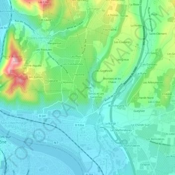
Name: Torras topographic map, elevation, terrain.
Average elevation: 171 m
Minimum elevation: 116 m
Maximum elevation: 334 m
Thank you for supporting this site ❤️
Make a donation
Make a donation
Other topographic maps
Click on a map to view its topography, its elevation and its terrain.
Ancien Lagunage
France > Auvergne-Rhône-Alpes > Drôme > Larnage > Les Sautons et Chave
Average elevation: 219 m