
Thank you for supporting this site ❤️
Make a donation
Make a donation
Fords Prairie topographic map
Click on the map to display elevation.
Thank you for supporting this site ❤️
Make a donation
Make a donation
About this map
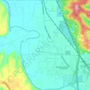
Name: Fords Prairie topographic map, elevation, terrain.
Location: Fords Prairie, Lewis County, Washington, United States (46.71673 -123.03305 46.76458 -122.97546)
Average elevation: 67 m
Minimum elevation: 37 m
Maximum elevation: 176 m
Thank you for supporting this site ❤️
Make a donation
Make a donation
Other topographic maps
Click on a map to view its topography, its elevation and its terrain.
Thank you for supporting this site ❤️
Make a donation
Make a donation
Thank you for supporting this site ❤️
Make a donation
Make a donation