
Thank you for supporting this site ❤️
Make a donation
Make a donation
Falls of Rough topographic map
Click on the map to display elevation.
Thank you for supporting this site ❤️
Make a donation
Make a donation
About this map
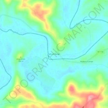
Name: Falls of Rough topographic map, elevation, terrain.
Location: Falls of Rough, Breckinridge County, Kentucky, United States (37.57005 -86.56887 37.61005 -86.52887)
Average elevation: 159 m
Minimum elevation: 128 m
Maximum elevation: 246 m
Thank you for supporting this site ❤️
Make a donation
Make a donation
Other topographic maps
Click on a map to view its topography, its elevation and its terrain.