
Sarıyahşi topographic map
Interactive map
Click on the map to display elevation.
Sarıyahşi
Sarıyahşi is a town and district of Aksaray Province in the Central Anatolia region of Turkey, at a distance of 110 km (68 mi) from the province seat of Aksaray. According to 2000 census, population of the district is 12,120 of which 7,751 live in the town of Sarıyahşi, and the remainder in surrounding villages.[3] The district covers an area of 280 km2 (108 sq mi),[4] and lies at an average elevation of 870 m (2,854 ft).
About this map
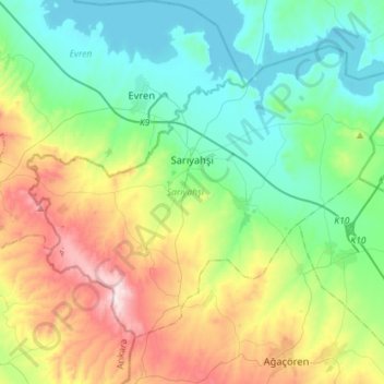
Name: Sarıyahşi topographic map, elevation, terrain.
Location: Sarıyahşi, Aksaray, Central Anatolia Region, Turkey (38.88204 33.72315 39.05093 34.00818)
Average elevation: 1,057 m
Minimum elevation: 841 m
Maximum elevation: 1,559 m
Other topographic maps
Click on a map to view its topography, its elevation and its terrain.
Adana
Heading west across Cilicia from Adana, the path to Tarsus crosses the foothills of the Taurus Mountains, eventually reaching an altitude of nearly 1,200 metres (4,000 ft) while passing through the Cilician Gates (Turkish: Gülek Boğazı), a rocky mountain pass functioning as the main artery to the Turkish…
Average elevation: 61 m
Ankara
Ankara has a cold semi-arid climate (Köppen climate classification: BSk). Under the Trewartha climate classification, Ankara has a middle latitude steppe climate (BSk). Due to its elevation and inland location, Ankara has cold and snowy winters, and hot and dry summers. Rainfall occurs mostly during the…
Average elevation: 1,082 m
Istanbul
Istanbul, located in northwestern Turkey, is a city that is uniquely situated across two continents, Europe and Asia, divided by the Bosphorus Strait. The city’s topography is characterized by a complex blend of hills, valleys, and coastal plains, which create a varied and scenic landscape. The European side…
Average elevation: 55 m