
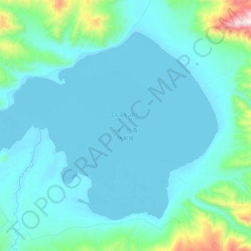
仁青休布错 topographic map
Interactive map
Click on the map to display elevation.
About this map
Name: 仁青休布错 topographic map, elevation, terrain.
Location: 仁青休布错, 丁什线, 仲巴县, 日喀则市, 西藏自治区, 中国 (31.20325 83.31525 31.35100 83.54475)
Average elevation: 4,886 m
Minimum elevation: 4,757 m
Maximum elevation: 5,877 m
仁青休布错(藏语:རིན་ཆེན་ཤུབས་མཚོ,威利:rin chen shubs mtsho,THL:Rinchen Shuptso)位于中国西藏自治区日喀则市仲巴县境内,地处仲巴县北部,冈底斯山北麓,湖面海拔4756米,面积187.1平方公里。湖水主要靠冰雪融水径流补给。湖西南岸有祝地臧布三角洲平原,其余湖岸为山地。
Other topographic maps
Click on a map to view its topography, its elevation and its terrain.