
Make a donation
Seaside topographic map
Click on the map to display elevation.
Make a donation
Seaside
Seaside, formerly East Monterey, is a city in Monterey County, California, United States, with a population of 32,366 as of the 2020 census. It is located 2.25 miles (3.6 km) east-northeast of Monterey, at an elevation of 33 feet (10 m), and is the home of California State University, Monterey Bay (CSUMB), UC MBEST Center, and the Monterey College of Law, which are located on the site of the former military base Fort Ord. Also on the site are the Bayonet and Black Horse golf courses, now open to the public and host to PGA Tour events, including the 2012 PGA Professional National Championship. Seaside is the gateway to Fort Ord National Monument, created on April 20, 2012.
Make a donation
About this map
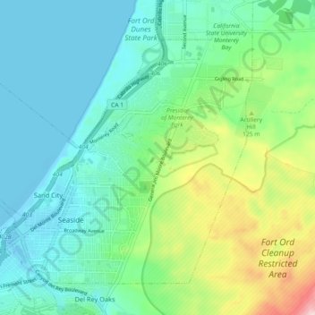
Name: Seaside topographic map, elevation, terrain.
Location: Seaside, Monterey County, California, 93955, United States (36.59681 -121.87991 36.65474 -121.78988)
Average elevation: 69 m
Minimum elevation: -7 m
Maximum elevation: 275 m
Make a donation
Other topographic maps
Click on a map to view its topography, its elevation and its terrain.
Bradley
United States > California > Monterey County
Bradley is an unincorporated community and census-designated place (CDP) in Monterey County, California, on the Salinas River 14 miles (23 km) south-southeast of San Ardo and 20 miles (32 km) north of Paso Robles. Bradley sits at an elevation of 548 feet (167 m). The population was 69 at the 2020 census, down…
Average elevation: 190 m