
Thank you for supporting this site ❤️
Make a donation
Make a donation
Madison County topographic map
Click on the map to display elevation.
Thank you for supporting this site ❤️
Make a donation
Make a donation
About this map
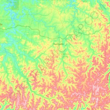
Name: Madison County topographic map, elevation, terrain.
Location: Madison County, Arkansas, United States (35.75975 -93.96305 36.30730 -93.44568)
Average elevation: 493 m
Minimum elevation: 336 m
Maximum elevation: 779 m
Thank you for supporting this site ❤️
Make a donation
Make a donation
Other topographic maps
Click on a map to view its topography, its elevation and its terrain.