
Montquintin topographic map
Interactive map
Click on the map to display elevation.
About this map
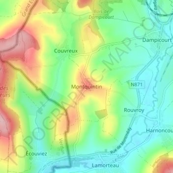
Name: Montquintin topographic map, elevation, terrain.
Location: Montquintin, Rouvroy, Virton, Luxemburg, Wallonië, 6767, België (49.52447 5.45279 49.56447 5.49279)
Average elevation: 244 m
Minimum elevation: 186 m
Maximum elevation: 352 m
Het dorp ligt op een heuvel van 330 meter hoogte en kijkt uit over de omgeving van Virton, het dal van de Ton, en de cellulosefabriek van Harnoncourt.
Other topographic maps
Click on a map to view its topography, its elevation and its terrain.
Meix-devant-Virton
Meix-devant-Virton, Virton, Luxemburg, Wallonië, 6769, België
Average elevation: 284 m
Habay-la-Neuve
Habay-la-Neuve, Habay, Virton, Luxemburg, Wallonië, België
Average elevation: 404 m
Meix-le-Tige
Meix-le-Tige, Saint-Léger, Virton, Luxemburg, Wallonië, België
Average elevation: 357 m
Chantemelle
Chantemelle, Étalle, Virton, Luxemburg, Wallonië, 6742, België
Average elevation: 343 m
Florenville
Florenville, Virton, Luxemburg, Wallonië, België
Average elevation: 316 m
Saint-Mard
België > Luxemburg > Virton > Virton
Saint-Mard, Virton, Luxemburg, Wallonië, 6762, België
Average elevation: 272 m
Chassepierre
België > Luxemburg > Virton > Chassepierre
Chassepierre, Florenville, Virton, Luxemburg, Wallonië, België
Average elevation: 322 m
Sommethonne
België > Luxemburg > Virton > Sommethonne
Sommethonne, Meix-devant-Virton, Virton, Luxemburg, Wallonië, 6769, België
Average elevation: 276 m
Grandcourt
België > Luxemburg > Virton > Virton > Grandcourt
Grandcourt, Virton, Luxemburg, Wallonië, België
Average elevation: 315 m
Villers-la-Loue
België > Luxemburg > Virton > Villers-la-Loue
Villers-la-Loue, Meix-devant-Virton, Virton, Luxemburg, Wallonië, 6769, België
Average elevation: 264 m
Semois
België > Luxemburg > Virton > Les Bulles
Semois, Les Bulles, Chiny, Virton, Luxemburg, Wallonië, 6811, België
Average elevation: 332 m