
Thank you for supporting this site ❤️
Make a donation
Make a donation
Pujut topographic map
Click on the map to display elevation.
Thank you for supporting this site ❤️
Make a donation
Make a donation
About this map
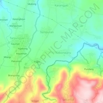
Name: Pujut topographic map, elevation, terrain.
Location: Pujut, Batang, Central Java, 51271, Indonesia (-7.04786 109.95578 -7.00786 109.99578)
Average elevation: 304 m
Minimum elevation: 202 m
Maximum elevation: 485 m
Thank you for supporting this site ❤️
Make a donation
Make a donation
Other topographic maps
Click on a map to view its topography, its elevation and its terrain.