
Make a donation
Yantai topographic map
Click on the map to display elevation.
Make a donation
Yantai
Yantai is located along the north coast of the Shandong Peninsula, south of the junction of Bohai Sea and Yellow Sea and parallel to the southern coast of Liaoning. The topographical breakdown consists of.
Make a donation
About this map
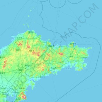
Name: Yantai topographic map, elevation, terrain.
Location: Yantai, Shandong, 264000, China (36.06645 119.54889 38.55837 121.92903)
Average elevation: 30 m
Minimum elevation: -2 m
Maximum elevation: 951 m
Make a donation
Other topographic maps
Click on a map to view its topography, its elevation and its terrain.
Make a donation
Make a donation
Qingdao
Qingdao is located on the south facing coast of the Shandong Peninsula (German: Schantung Halbinsel). It borders three prefecture-level cities, namely Yantai to the northeast, Weifang to the west, and Rizhao to the southwest. The city's total jurisdiction area occupies 10,654 square kilometres (4,114 sq mi),…
Average elevation: 25 m
Make a donation
Make a donation