
Thank you for supporting this site ❤️
Make a donation
Make a donation
Gard topographic map
Click on the map to display elevation.
Thank you for supporting this site ❤️
Make a donation
Make a donation
About this map
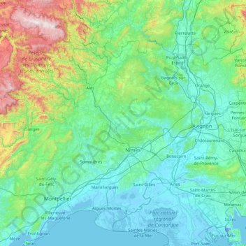
Name: Gard topographic map, elevation, terrain.
Location: Gard, Occitania, Metropolitan France, France (43.46020 3.26190 44.45966 4.84553)
Average elevation: 233 m
Minimum elevation: -12 m
Maximum elevation: 1,695 m
Thank you for supporting this site ❤️
Make a donation
Make a donation
Other topographic maps
Click on a map to view its topography, its elevation and its terrain.