
Garrigue Basse topographic map
Interactive map
Click on the map to display elevation.
About this map
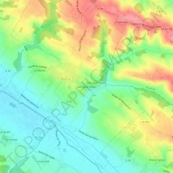
Name: Garrigue Basse topographic map, elevation, terrain.
Average elevation: 168 m
Minimum elevation: 128 m
Maximum elevation: 224 m
Other topographic maps
Click on a map to view its topography, its elevation and its terrain.
Garrigue Haute
France > Occitanie > Haute-Garonne > Bazus
Garrigue Haute, Bazus, Toulouse, Haute-Garonne, Occitanie, France métropolitaine, 31380, France
Average elevation: 171 m