
Thank you for supporting this site ❤️
Make a donation
Make a donation
Observatory Hill topographic map
Click on the map to display elevation.
Thank you for supporting this site ❤️
Make a donation
Make a donation
About this map
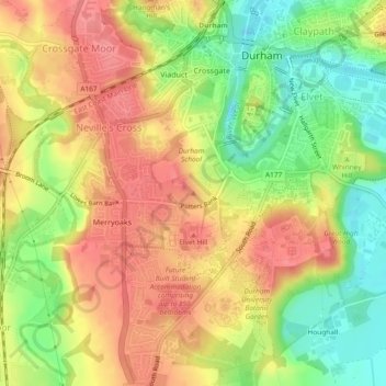
Name: Observatory Hill topographic map, elevation, terrain.
Average elevation: 73 m
Minimum elevation: 29 m
Maximum elevation: 107 m
Thank you for supporting this site ❤️
Make a donation
Make a donation
Other topographic maps
Click on a map to view its topography, its elevation and its terrain.
Flass Vale Local Nature Reserve
United Kingdom > England > County Durham > Durham
Average elevation: 81 m