
Thank you for supporting this site ❤️
Make a donation
Make a donation
Mary's Peak topographic map
Click on the map to display elevation.
Thank you for supporting this site ❤️
Make a donation
Make a donation
About this map
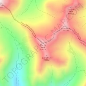
Name: Mary's Peak topographic map, elevation, terrain.
Location: Mary's Peak, Kittitas County, Washington, United States (47.41523 -120.87191 47.41533 -120.87181)
Average elevation: 1,717 m
Minimum elevation: 1,309 m
Maximum elevation: 2,081 m
Thank you for supporting this site ❤️
Make a donation
Make a donation
Other topographic maps
Click on a map to view its topography, its elevation and its terrain.