
Thank you for supporting this site ❤️
Make a donation
Make a donation
Untereschach topographic map
Click on the map to display elevation.
Thank you for supporting this site ❤️
Make a donation
Make a donation
About this map
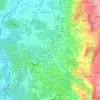
Name: Untereschach topographic map, elevation, terrain.
Average elevation: 462 m
Minimum elevation: 410 m
Maximum elevation: 569 m
Thank you for supporting this site ❤️
Make a donation
Make a donation
Other topographic maps
Click on a map to view its topography, its elevation and its terrain.
88213
Deutschland > Baden-Württemberg > Landkreis Ravensburg > Ravensburg > Schmalegg > Ganter
Average elevation: 507 m
Schmalegg
Deutschland > Baden-Württemberg > Landkreis Ravensburg > Ravensburg
Schmalegg liegt auf einer Anhöhe, die das Schussental überblickt.
Average elevation: 540 m
Schwalbenbach
Deutschland > Baden-Württemberg > Landkreis Ravensburg > Ravensburg > Weißenau
Average elevation: 468 m