
Thank you for supporting this site ❤️
Make a donation
Make a donation
El Casco topographic map
Click on the map to display elevation.
Thank you for supporting this site ❤️
Make a donation
Make a donation
About this map
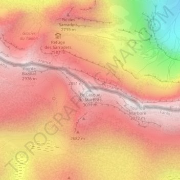
Name: El Casco topographic map, elevation, terrain.
Location: El Casco, Sobrarbe, Huesca, Aragón, España (42.68772 -0.02681 42.68782 -0.02671)
Average elevation: 2,514 m
Minimum elevation: 1,607 m
Maximum elevation: 2,981 m
Thank you for supporting this site ❤️
Make a donation
Make a donation
Other topographic maps
Click on a map to view its topography, its elevation and its terrain.