
Make a donation
Uxbridge topographic map
Click on the map to display elevation.
Make a donation
Uxbridge
The town is 30.4 square miles (79 km2), of which 0.8 square miles (2.1 km2), or 2.74%, is water. It is situated 39.77 miles (64.00 km) southwest of Boston, 16 miles (26 km) southeast of Worcester, and 20 miles (32 km) northwest of Providence. Elevations range from 200 feet (61 m) to 577 feet (176 m) above sea level. It borders Douglas, Mendon, Millville, Northbridge, and Sutton, Massachusetts, plus the Rhode Island towns of Burrillville and North Smithfield.
Make a donation
About this map
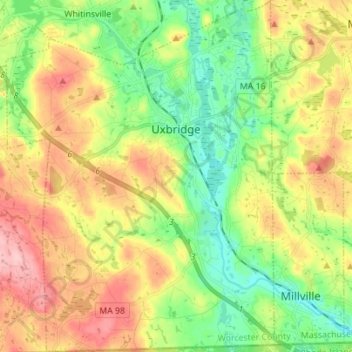
Name: Uxbridge topographic map, elevation, terrain.
Location: Uxbridge, Worcester County, Massachusetts, United States (42.01153 -71.69667 42.11428 -71.59110)
Average elevation: 115 m
Minimum elevation: 55 m
Maximum elevation: 195 m
Make a donation
Other topographic maps
Click on a map to view its topography, its elevation and its terrain.
June Street
United States > Massachusetts > Worcester County > Worcester > June Street
Average elevation: 181 m
Make a donation