
Make a donation
Idbury topographic map
Click on the map to display elevation.
Make a donation
About this map
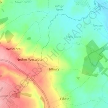
Name: Idbury topographic map, elevation, terrain.
Location: Idbury, West Oxfordshire, Oxfordshire, England, United Kingdom (51.86627 -1.68430 51.89978 -1.62284)
Average elevation: 147 m
Minimum elevation: 103 m
Maximum elevation: 220 m
Make a donation
Other topographic maps
Click on a map to view its topography, its elevation and its terrain.
Great Park
United Kingdom > England > Oxfordshire > West Oxfordshire > Long Hanborough
Average elevation: 94 m
Ledwell
United Kingdom > England > Oxfordshire > West Oxfordshire > Sandford St. Martin
Average elevation: 142 m
Make a donation
Eynsham Mill
United Kingdom > England > Oxfordshire > West Oxfordshire > Eynsham
Average elevation: 71 m
Shipton-under-Wychwood
United Kingdom > England > Oxfordshire > West Oxfordshire
Average elevation: 131 m
Make a donation
Make a donation
Upper Milton
United Kingdom > England > Oxfordshire > West Oxfordshire > Milton-under-Wychwood
Average elevation: 153 m
Make a donation