
Make a donation
Catawba Colony topographic map
Click on the map to display elevation.
Make a donation
About this map
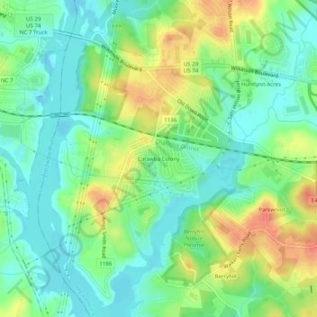
Name: Catawba Colony topographic map, elevation, terrain.
Average elevation: 193 m
Minimum elevation: 173 m
Maximum elevation: 225 m
Make a donation
Other topographic maps
Click on a map to view its topography, its elevation and its terrain.
Coulwood Park
United States > North Carolina > Mecklenburg County > Charlotte > Coulwood Hills
Average elevation: 211 m
Idlewild Farms
United States > North Carolina > Mecklenburg County > Charlotte
Average elevation: 222 m
Make a donation
Mecklenberg Wildlife Club Lake
United States > North Carolina > Mecklenburg County > Charlotte
Average elevation: 214 m
Mecklenburg County Sportsplex at Matthews
United States > North Carolina > Mecklenburg County > Matthews > Club View Acres
Average elevation: 225 m
Beverly Woods East
United States > North Carolina > Mecklenburg County > Charlotte
Average elevation: 203 m
Make a donation
North Mecklenburg Park
United States > North Carolina > Mecklenburg County > Huntersville
Average elevation: 238 m
Carmel Road Park
United States > North Carolina > Mecklenburg County > Charlotte > Carmel Woods
Average elevation: 198 m
Make a donation
Deschutes Pond
United States > North Carolina > Mecklenburg County > Huntersville
Average elevation: 224 m
President James K. Polk State Historic Site
United States > North Carolina > Mecklenburg County > Pineville
Average elevation: 175 m