
Make a donation
Rioja topographic map
Click on the map to display elevation.
Make a donation
Rioja
The mountains in La Rioja are part of the Iberian System. This mountain range extends to the south of the Ebro river, parallel to it at a distance of about 40 to 60 km (25 to 37 miles), with altitudes ranging between 1,000 and 2,000 m (3,300 and 6,600 feet). From the mountain range the Sierra de la Demanda runs northwards, into the heart of La Rioja, incorporating Monte San Lorenzo which, at 2,271 m (7,451 ft), is the highest peak in the province. Other mountains include Sierra de Camero Viejo, Sierra de Camero Nuevo, Sierra de Cebollera, and Picos de Urbión.
Make a donation
About this map
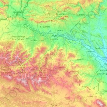
Name: Rioja topographic map, elevation, terrain.
Location: Rioja, Spain (41.91903 -3.13427 42.64426 -1.67870)
Average elevation: 873 m
Minimum elevation: 269 m
Maximum elevation: 2,298 m
Make a donation
Other topographic maps
Click on a map to view its topography, its elevation and its terrain.
Madrid
Spain > Community of Madrid > Área metropolitana de Madrid y Corredor del Henares > Madrid
Average elevation: 650 m
Make a donation
Soil
Spain > Autonomous Community of the Basque Country > Montaña Alavesa/Arabako Mendialdea
Average elevation: 898 m
Alegranza Island
The area is 10.2 km². The island features a volcano with a crater of about 1.1 km in diameter and an altitude of 289 m. The second highest is Montaña de Lobos at 256 m and following La Rapagura. The northern portion is mainly flat.
Average elevation: 39 m
Make a donation
Huesca
Spain > Aragon > Hoya de Huesca / Plana de Uesca
Huesca lies on a plateau in the northern region of Aragón, with an elevation of 488 m (1,601 ft) above sea level. Close to the city lie the Sierra de Guara mountains, which reach 2,077 m. The geographical coordinates of the city are: 42° 08´ N, 0° 24´ W.
Average elevation: 589 m
Make a donation
Make a donation
Mijas
Spain > Andalusia > Costa del Sol Occidental > Mijas > Mijas
The climate changes gradually with increasing elevation in the mountains. Temperatures can drop to 10 °C (50 °F). In the peaks, over 600 m (2,000 ft) high, some ice may form in winter, while precipitation increases to almost 800 mm (32 in).
Average elevation: 447 m
Make a donation
Make a donation
Caldes d'Estrac
Spain > Catalonia > Maresme > Caldes d'Estrac > Caldes d'Estrac
Average elevation: 57 m
Park Beach
Spain > Andalusia > Costa del Sol Occidental > Estepona > Park Beach
Average elevation: 13 m
Make a donation