
Thank you for supporting this site ❤️
Make a donation
Make a donation
Columbia Heights topographic map
Click on the map to display elevation.
Thank you for supporting this site ❤️
Make a donation
Make a donation
About this map
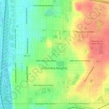
Name: Columbia Heights topographic map, elevation, terrain.
Average elevation: 282 m
Minimum elevation: 252 m
Maximum elevation: 317 m
Thank you for supporting this site ❤️
Make a donation
Make a donation
Other topographic maps
Click on a map to view its topography, its elevation and its terrain.
Rum River North County Park
United States > Minnesota > Anoka County > Saint Francis
Average elevation: 279 m
Thank you for supporting this site ❤️
Make a donation
Make a donation